Thursday, June 17, 2010

15th & Final Training Hike - Top of Palmer, Mt. Hood June 12, 2010

It was sort of a bitter sweet day today as this was the last training hike we would do together as the entire 201 Reach The Summit Team.  But what a gorgeous day it was!  After weeks of rain, the weather had swung to the other end of the pendulum.

The Timberline Lodge operated the ski resort on Palmer Glacier on the southern slope of Mt. Hood.  We would hike today from the Timberline Lodge at just shy of 6,000' to the upper limit of the non-backcountry area around 8,500'.  With the temperature expected to approach the 60s even at this elevation, we anicipated the snow to be loose and slushy so it was a good thing that we were carrying snowshoes with us.  There were some avalanche concerns in the backcountry area because of the new snow falls in the preceding days followed by the warm weather today however it was determined not to be a concern of ours as we were remaining in the ski resort area where the snow had been meticulously groomed.

I wanted to simulate my Mt. Adams climb today so I decided to pack everything I'd carry on that day, my sleeping bag & pad, ice axes helmet, harness, crampons, etc., etc., on top of everything else I had been carrying on all our training hikes (though I won't be carrying snowshoes on my real climb).  It turned out be roughly 55lbs altogether.

As usual, we all met up in the parking lot of a grocery store nearby and went through the usual rituals of getting briefed by our training hike supervisor, Joe, and splitting into three groups, the fast group, the medium group, and the "endurance" group.  Because of the weight I would be carrying today, I was tempted to join the "endurance" group but I decided against it and stuck with the medium group led by Matt, Leisa and Joe.  Altogether we started with 13 people in the medium group. 

I always enjoyed the picturesque drive on the Hwy 26 looking at a windshield full of Mt. Hood.  Sometimes, I had to try consciously not to get distracted and thus not to become another source of crater on its slope actually.  Charles, the climber with whom I shared the ride, no doubt appreciated that.  In today's amazingly clear air, the mountain looked even closer than it actually was.  There was not even a spec of puffy clouds anywhere or standing lenticular clouds that would indicate strong wind aloft.  I couldn't wait to get on the mountain!!!!

Once we strapped our gears onto ourselves, we gathered in front of the climber registration at the lodge.  You'd be required to register and get a permit for your climbing party if you were to venture into the backcountry area.  It wouldn't cost anything to do this but this was so that the rescue folks would have some sort of idea who and how many people were up there in case some unfortunate things happened.  (Not to mention how many permanent bivy sacks they'd need to bring with them...)

Now we were ready to go out there.  But as soon as we set our feet on the snow, it was pretty apparent that we'd need to put on our snowshoes right away.  The snow was as soft as Seven Eleven's Slurpee.  Without my snowshoes, I would have definitely kept sinking into it on every step I took with this heavy pack on my back and all. 

This was also a good chance for me to try out the "heel lifters" that came with my snowshoes.  They were metal bars that flipped up underneath my heels to give my heels few inches of lifts.  The idea was that, by having the angles of my feet relative to the snow slope somewhat flatter, the climbing will be more like going up stairs than walking up a steep slope thus keeping my calves happier.  And it worked!!  In fact, it worked fantastically well.  I was totally sold on this little feature. 

Anyway, the familiar slog commenced.  The first 10 minutes was always the roughest until my heart revved up to speed.  From there on, it was still tough but manageable. I just settled into a nice constant rhythm of rest stepping - putting one foot in front of the other, transferring my weight on it, and locking the knee for a brief moment, over and over.

The "trail", if you could call it that, paralleled the skiing and snowboarding area all the way up the slope.  It was more of an alley for the snowcats to travel up and down on than a trail actually.  Next to the trail, there was a bunny slope as well as jump platforms for freestylers in addition to groomed slopes.  It was nice distraction from otherwise the monotonous climbing task watching the skiers and the snowboarders launch into the air.  Now, I didn't know a lot about freestyling but it's probably safe for me to guess that the old saying, "take off is optional, landing is mandatory", applied in this situation as well.

As you can see from the pictures of us at our gear check, we were quick to take off any extra layers we started in.  Because the snow reflected 80% of the sun light, which was twice as strong at this elevation as at the sea level to begin with, the glacier had instantly turned into a broiler in this windless air that cooked us relentlessly, not only from above but also from directly below us.  It was not too long before the mixture of sweat and sunscreen started pouring down my face, rendering the sun glasses useless and stinging my eyes in the process.  (Note to myself - use a bandanna from now on!) 

One different thing about climbing mountains from hiking is that, more often than not, you would be able to see where you were headed for the entire time you were climbing.  Especially in good weather like this obviously.  And it was very difficult to guage the distance.  Here we were on Mt. Hood, everything looked so much closer than it appeared in the vastness of Palmer Glacier with gigantic Mt. Hood's headwalls looming right above us.

Then we popped out onto a small col only several hundred feet below the top of Palmer through which the wind accelerated owing to the venturi effect.  All that body heat we could not seem to get rid of fast enough up until now was suddenly valuable commodity.  However, that did not last very long as we soon reached our today's destination, the top of Palmer.


We hurriedly put on our jackets back on before we got chilled to our bones once we stopped.  Then it was a reward time!  Sitting against the snow at the backcountry boarder, we chewed on the lunch of our choices together for the last time enjoying the southern view from the 8,500' elevation.  In this seemingly unlimited visibility, the mountain ranges of the central Oregon was clearly visible from here, with Mt. Jefferson being the most prominent in the foreground, and Sisters and Broken Tops defining the ruggedness of the Cascade Range. 

At this elevation where the temperature was low enough for the snow to remain somewhat firmer, we started plunge stepping down rather than putting our snowshoeing.  We also saw other climbers glisadeing down which was probably the next best thing to skiing down.  Although we were no longer subjected to the strenuousness of climbing, it still was difficult to proceed because of the unstable snow condition.  But who cares about that when you're having fun with cool people like us!!  Ha!


So now that we've done our final training hike, what happens now?  Like I mentioned earlier, the big weekend for the Mt. Hood climbers are coming up at the end of this month.  After that, I am looking forward to joining them at our celebration party where we will be letting loose! 

But in the mean time, we the Mt. Adams climbers will continue to have our training hikes, at least three of them, through the end of July.  This weekend, we will revisit Nesmith Point, followed by a hike from the Timberline Lodge (5,800') to the Crater Rock (10,000') on Mt. Hood.  At some point in July, we will have another overnight training event somewhere on Mt. Hood.  Also, a group of us are going to climb Mt. St. Helens few days after the Independence Day as well (non-RTS).



Thursday, June 10, 2010

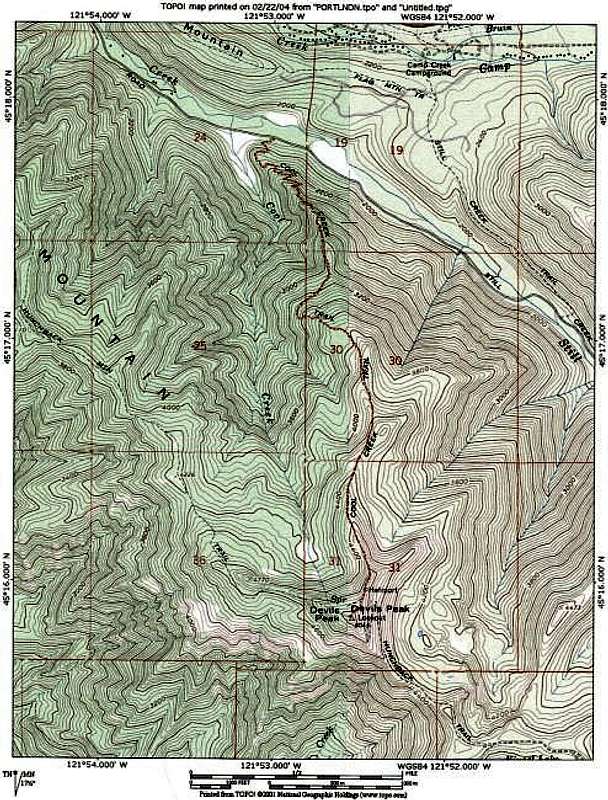
14th Training Hike - Devil's Peak, Cold Creek Trail June 6th, 2010

I've heard people say the weather on the climb would be good if it's crappy on training hikes.  I truly hope so after this very wet and muddy hike.  Where is the summer anyway?? It's already June and we continued to have spring like weather here in the northwest. 

I was feeling not as confident as I had felt on most of our past hikes when I stepped onto the trail in the morning.  I had not been able to do much of physical activities for this past couple of weeks due to a little knee issue that crept up on me.  So I was rather pleasantly surprised at how good I felt on this hike, notwithstanding its difficulty.

I brought a pair of YakTraks, traction devices that strapped onto the bottom of my hiking boots, however I left them in my car in my haste to get on with the hike.  They would have come in very handy today.  Our supervisor also warned us that there would be lots of roots and downed trees along the way, making it somewhat of an obstacle course.

The trail started off very steeply right from the trailhead.  For some reason, I was way overdressed for the occasion and, in a matter of several minutes, I felt like I had a kettle full of boiling water tucked under my shell.  Apparently, others needed to take early gear check breaks as well.  And that's what we did.  Actually, we knew that it would be almost pointless to be wearing a waterproof shells as, from our past experiences, we had known that we would be utterly wet inside and out anyway on a day like this with 1,000% humidity.  So we all decided to to pack them up and layered down to nothing but our base layers.  This worked pretty well - the rain had backed off a bit on its relentlessness mostly by this time and it was warm enough. 

Devil's Peak was located in the southwestern foothills of Mt. Hood in its wilderness area along a small backroad just off of Hwy 26.  If not for the sign, we would have completely missed the trailhead hidden in the bushes actually.  Although one might imagine from the name of the trail, Cool Creek Trail, that it would  follow right along a nice mountain stream cascading down boulders, we found out that it was not exactly like that at all.  However I am going to keep this one on my list of places I must revisit later in the season when I can expect dryer weather for the views it offers throughout the hike.  Unlike our last hike at Ruckel Creek Trail (another misleading name), this trail had actually had a final destination around 4,800' that we could look forward to reaching.  I think this helped keeping our morals up while slogged up 3,200' over the course of 4.1 miles or so.

Like I mentioned earlier, we did see lots of fallen trees blocking our path.  But it was fairly easy to overcome them by going over or under their trunks.  I actually enjoyed having varying features like these as it made the hike a bit more enjoyable.  We only took one 5 minute break along the way.  Our hiking leader, Eric, later took a vote to see if we wanted to take the second break and we unanimously decided to keep pushing instead. 

Somewhere around 4,000', we started to see some snow patches on the ground.  Soon, the snow covered the entire ridge this trail followed and our paces slowed down significantly.  This was where we appreciated what we learned during our climbers clinic last month - the value of making a good platform as we took each step, particularly when our footings were made somewhat precarious on half frozen snow pack.  Oddly, I ended up straying off form the path at one point so I had to cross over a woody section in order to rejoin them.

Soon we found ourselves at the summit of Devil's Peak where a small lookout stood.  Unlike at the trail head, it was freezing cold there especially wearing only a base layer that had been completely soaked in rain and sweat as we remained in the clouds pretty much the whole way up.  The first order of my business was to change into a dry base layer and put back on the mid and outer layer immediately before I lost too much of my body heat.  And what a difference it made!  It certainly made my lunch break far more enjoyable.  A note to myself - get a light weight thermos.  A cup of hot coco was the only thing missing from otherwise a complete picture. 

I went up into the lookout structure to see what it looked like.  It was actually pretty nice complete with a small table, a wood burning stove and a couple of beds!!  I could see this would be a very good place to be if I found my hike here in the snowier season turned into an imprompeau overnight trip.  It surely would beat bivying - that's for sure!

So what were those sayings - "What goes up must come down", "Summiting is optional, descent is mandatory", "What floats up must sink"??  Yes indeed.  It was a lot more precarious going down on this trail than climbing up as you probably can imagine.  The constant rain has made the snow near the top much slicker and the muddy trail lot looser.  Those  roots sticking out everywhere didn't exactly help either.  But we just had to do it - that's all.  The bottom of my feet were starting to get pretty sore by the time we were half way down the mountain.  All I could think about was how a hot shower was going to feel sooooo goooooood after getting home.  I couldn't wait!! 

Next week, we will be hiking together as a whole Reach The Summit team for the last time from the Timberline Lodge to about half way up to the summit of Mt. Hood.  After that, 9 of us climbing Mt. Adams will continue to train through the end of July.

It's time to bring it all home!  Stay tuned...

Tuesday, June 8, 2010

13th Training Hike - Ruckel Creek May 22nd, 2010

Did someone say it was a butt kicker of hike?? May I take the liberty to edit it a little in order to reflect the reality better by saying it was an @$$ kicker of hike?? To top it off, it was one of those hikes to nowhere that had no particular final destination. The sole purpose of its existence was to serve those who had not gotten their seconds after eating their own guts. And to give another chances to those who thought they already had their seconds in the past.  Scanning online about what other people said about this place, I found one of them said "Every foot of Oregon's Ruckel Creek Trail is a poem."  Huh??!! 

In terms of numbers, Ruckel Creek Trail launched almost 3,800' vertically over the distance of about five miles via its rather precarious path.  We were thankful that the weather held off while we were out there as it would have made it a muddy mess as if we would need that.

The only thing that made it mildly interesting was the variety of features the trail showed us.  Though we stayed almost entirely in the forests, there were meadowy sections with rocky features, including the rocky pits that were made over 1,000 years ago by the native Americans where we took a little breather.  Also there were some wild flowers blooming to look at and few breaks in the woods where we had the bird's eye views of the Gorge.

You must excuse me for not having stayed on top my photo taking duties while we slogged on upward to nowhere. We started to see some patches of snow and even a little flurries here and there once we got near the end of hike.  Later, I found out that we were actually at a place called Benson Plateau where the terrain leveled off for miles.  It got significantly colder at the end of the hike - so much so that most of us were pulling out down jackets out of our packs to keep warm while we devoured our food. 

On a hike like this with a wickedly steep trail, it was very strenuous to climb to put it mildly of course but the real kicker came going the other way.  And this was when we had to pay deliberate and close attention to what we are doing most.  It was easy to roll ankles, twist knees, do face plants, etc. because we were pretty fatigued. Generally speaking, 80% of injuries occured during the descent phase as a matter of fact and thus this was where our fitness levels counted the most - the less we were fatigued, the better our chances of making it down in one piece.

Just as I was starting to wonder if I should have knee replacement surgeries scheduled for myself, we were back down to where we started. Or so we thought - I forgot that there was a teaser section there that we still had to climb back up a little before we found the parking lot. 

Later that week, our training hike supervisor sent us emails to ask if we wanted to do Nesmith Point or Ruckel Creek again for one of our hikes in June.  I let you guess which one I voted for.

Next week, we'll be hiking Devil's Peak in the foothills of Mt. Hood, which we missed earlier because of the winter like weather condition.  Stay tuned!!


Wednesday, June 2, 2010

Reach The Summit BBQ Party - May 21st, 2010


Thank You!!


We had a great turn out and had a blast this past Friday chilling at Burdigala Wine in Sellwood listening to awesome music while we chowed down on tasty BBQ and sipped delicious wine! Geoff and Terry would like to thank all of you who came to and participated in this fundraiser despite the wet weather. We have raised $500 to benefit the American Lung Association!


Event Sponsors
  • Venue:
Burdigala Wine, Didier Sudre
  • BBQ Grill:
Traeger Grills
  • Entertainment:
Hutson
  • Press:
The Oregonian
  • Raffle:
Arbonne International, Kelly Hobson
ChiRoweYoga, Linda Rowe
Hilton Garden Inn, Beaverton, MacKenzie Upchurch
Image by Karen Radique, Karen Radique
In Great Spirits, Sharona Tsubota
Juice Plus+, Beth Genly
Kim's Therapeutic Massage, Kim Hess, LMT
Marsha Cosgrove - Hair Stylist & Color Specialist, Marsha
Cosgrove
Memories by Harvey, Harvey Thomas
Notes of Celebration, Linda Smith
Phoenix Inn Suite - Beaverton, DeEsta Denver
Poise Studio, Sarah Balmer & Victoria Marchese
Photo Images by Susan Gould, Susan Gould
The Plumbers Inc., Judah Hamnes

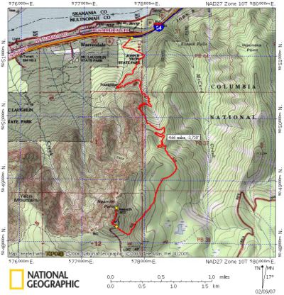
12th Training Hike - Nesmith Point May 16, 2010

I'm finally catching up with my training hike blogs that I slacked off in the midst of the BBQ Party preparations.

Although many of us were kind of sleep deprived and tired from the night hike training we had just done only the day before, we showed up again to take some more at Nesmith Point.

The training location was changed to Nesmith Point because we had already hiked Dog Mountain twice. It would be the longest and the highest one we would do yet at 3,800' of elevation gain over a five mile trail each way. (Of course we had been spoiled by all those hikes in the past with incredible views at every other turn too. So a hike for the sake of being butt kicked was probably long over due at this point..)

The first mile or so from the parking lot took us through dense forests to a junction with another trail called Gorge Trail. From there on, we got to savor the sweet suffering we asked for, step by step, on the countless switchbacks that promised to dish out the relentlessly steep climb up a gully. Once we left the gully, the trail took us traversing a steep slope that was seemingly almost vertical, followed by another series of switchbacks, though short, back up the ridge.


So was the hike all about the building our mountaineer characters? There were few brief moments that allowed us to take our minds off the gradual build-up of lactic acid in our muscle tissues. For instance, there were many wild flowers like trilliums and wild roses that were absolutely lovely all along the trail. We also got to see some views of the Gorge through the breaks in the vegetations with Mt. Adams off to the distance which was still covered in snow. (Sorry, it was a bit too hazy to capture it on my camera.)

About 1,000' (?) or so before the summit, we took a nice break in a rocky section where we refueled before the final push. I was surprised about how good I was still feeling at this point despite the lack of sleep. From there, we kept following the trail that eventually intersected with an old road that was used to take people up in the early half of the last century. The summit was finally near. So where was it??

The climax of our hike was accentuated by the broken down outhouse that had been there for decades as I was told. Otherwise it was a small clearing that faced opposite to the direction of the Gorge.

I am going to cheat a little bit now and post a bunch of pictures at the bottom to call it a blog.

Our next hike is going to be at Ruckel Creek which has been described by one of our training hike assistants as "butt kicker of a hike." Stay tuned!!

Tuesday, June 1, 2010

Fundraising Goal Reached!!

Fund raised: $3,000

I have no words to describe my appreciation today.  It would have never been possible without the support provided in all forms by those who have stepped forward to go the distance with me in this extraordinary endeavour. And I have been truly humbled most of all by your graciousness displayed simply as fellow human beings.

Again, thank you.

Terry Tsubota
2010 Reach The Summit Climber, Mt. Adams

Wednesday, May 19, 2010

Night Hike Training May 15th, 2010


This was another one of our big training events that we looked forward to. It was not so much about training for fitness but more about getting used to doing things in the dark under our headlamps such as doing gear checks, putting on/off the crampons, adjusting the boots, etc., since we will be summitting under similar conditions on our actual climbs. Tonight, we would start our "simulated" climb from the Timberline Lodge and go up about 1,500' to a mountaineering hut called Silcox Hut where we would turn around and come back down.

Some of us had decided to go up to the Timberline Lodge early to get few hours of naps in before the hike. By the time I finished work and managed to get on the road, it was already past 4pm and the traffic on the freeway had already come to an agonizingly slow crawl. It took me over two hours to get to the lodge where an hour would usually be enough. Though the plan was to join everybody at 6pm to have a dinner with them before the nap, this obviously was not going to happen at this point. So I decided that I would stop at Ice Axe, a beer and burger joint in the area, where I had a $12 Philly sandwich, fries and a glass of ice tea to wash them down.

When I got up to the Timberline Lodge's parking lot, the one end of its overnight parking section was lined with cars with climbers in them getting some Zs already. I was somewhat surprised by the number of cars but I probably shouldn't have considering Mt. Hood was the second most climbed mountain in the world (the first was Mt. Fuji in Japan.) I backed my car into an open parking space, made sure it was in gear so that it wouldn't start rolling by accident while I'm sleeping in it, and hopped out of it to go use the facility in the lodge.

As I was walking up the inclined parking lot, I saw Marty and Kristen coming down from the lodge to their car. The weather was crystal clear that night and the visibility was unlimited in all directions. I saw Mt. Jefferson to the south and Mt. Hood looked a lot bigger than usual.

Now the challenge was to create a little nook in my car where I would be able to unroll my sleeping bag and pad, not to mention myself. If you've ridden in a Jeep Liberty before, you probably can see how awkward this arrangement would be. The fact that I had so much junk in my car didn't help either. I folded down one of the rear seats' seat backs so that it would make a small area that somewhat resembled a reclining hospital bed, except that it was only about 5' long. However, once I got settled into my sleeping bag, it really wasn't as bad as I thought it would be. In fact it was surprisingly comfortable even though I was having to curl up in a fetus position in order to fit in the space I just created. Geoff, a friend I met through Reach The Summit program, was also pulling up next to my car as I was fussing with my napping space.

"Quack, quack quack! Quack, quack, quack! Quack, quack, quack! ..." My alarm clock was already... well... quacking. It didn't feel like I fell asleep at all but I must have - two hours went by as if it was merely 15 minutes. In an hour or so, we were to meet up with the rest of the climbers in the climber registration area and start our climb around midnight. Where's the nearest bathroom anyway??

After nursing a hot cup of strong Earl Grey, I was all decked out in mountaineering gear and ready to start the hike. We split into three different groups as usual but, this time, there was no particular category, such as a fast group, an intermediate group or an "endurance group" since it was going to be fairly a short hike. Once we completed this process, we headed out to the Timberline Trail that stretched pretty much straight up from there to Silcox Hut. In 10 minutes or so, we stopped to check our gear and to strap on our crampons. The temperature outside was a bit high at around 50 degrees and the snow felt heavy and mushy under our feet.

Then the usual and familiar slog started. Step by step we started our way up the foothill of Mt. Hood. There were lots of other groups on the trail as well. All probably aiming to summit. At one of our breaks, we turned off our torches to look up and admired the dizzying display of stars in the new moon. I wish I could have taken pictures of them but they wouldn't even resemble any sort of justice anyway.

The major difference between the training hikes we had been doing and this hike was that the snow was so soft and mushy that it was sort of like walking on the beach. The fact that the snowcats had been chewing up the trail earlier didn't exactly help either. We also stopped as often as necessary to practice making adjustments to our plastic mountaineering boots. I think almost all of us hated the plastic boots because it felt much like walking around in ski boots. Not that we had much other choices.

By the time we reached the level slightly above the Silcox Hut, we were roughly around 7,000 in elevation where we turned around and started going down. The gradient of the slope seemed to significantly increase from that point on and many of the groups continuing higher were putting their harnesses on to be ready for their eventual roped traveling.

Going down was much rougher than climbing up. The snow was completely chewed up by then by both the foot traffic and the snowcats making it difficult to make any step even close to decent. Mercifully, it took only about an hour or so to make our way down to the Timberline Lodge. By then, I was ready to head home and to squeeze in few hours of Zs before I had to head back out for the volunteer activities I promised to attend that day. What a hike!!

As if this was not enough this weekend, our next hike is scheduled tomorrow, a day after this night hike, at Nesmith Point in the Columbia River Gorge. This will be our longest and toughest hike yet with the vertical elevation gain of 3,800 over a distance of 10 miles round trip. Stay tuned!!

Friday, May 7, 2010

10th Training Hike - Dog Mountain May 8th, 2010


The location for this lung and quad burning session was changed to Dog Mountain due to the winter like condition in the Mt. Hood area.


Under the crystal clear sky that would warm us up in its 70 degrees air today, we sucked it up and started pounding the trail that launched steeply via a series of switch backs until we reached a split in the trail where, once again, it offered us a choice between "More Difficult" and "Less Difficult." At glance, it would be somewhat deceiving to first-timers as the "More Difficult" trail continued from that point with a short flat section while the other one climbed on. I'm sure you can guess by now which way we went.


Jason led my group, the intermediate group, with good spirit. From the beginning, he did a great job of reminding us about the abundance of poison oak on both sides of the trail whenever we made brief stops to adjust our gear, etc. We were also very wary of any dog dragging a hiker as it most likely had been going in and out of the poison oak bushes and looking for some victims to brush up against.


Since we had been on this trail before on one of our training hikes, we were more zoned into the task of climbing than the last time and not getting distracted by the gorgeous scenery, I think. Not that that was much possible at the pace we were going. I was actually hoping to see a knoll covered by spring flowers as we broke out of the wooded section but it was obviously premature despite the warm weather today. There were some flowers blooming but not to the extent Dog Mountain was known for.


But we thoroughly enjoyed the panoramic view of the Columbia River Gorge while we devoured our feed at the summit. Especially after beating the time from our last hike here by 15 minutes, at 1:45 to slither up from the trail head to the top, gaining 2850' in elevation. That's 1,629'/hour!


Now the only carrots hanging in front of our noses were the nice tall cold ones down at Edgefield which had become our regular hang-out in this area. We were thankful that we started our hike early enough in the morning before the temperature shot up to bake anyone going up that south facing trail. It also helped that we descended via the "Less Difficult" trail flanked on the shadier side of Dog Mountain. About a half way down the mountain, we found Jennifer, Abby and Hilary sitting at a nice little trail side bench enjoying their lunches.


Edgefield was packed with weekend warriors and alike outside. Every single table was taken so we planted ourselves on the lawn just behind a huge water tower. The cool grass felt great after the rigorous exercises. Our waitress was nice enough to accommodate us there for much needed beverages and even some real food. Couldn't get much better than that!

Now that our climb dates are getting closer, we will be going back to Mt. Hood next weekend to get some night hike time under our belts. We will start climbing around midnight from Timberline Lodge to Silcox Hut where the Mt. Hood climbers will be spending a night just before their summit. Stay tuned!!

Sunday, May 2, 2010

8th Training Hike - Tilly Jane April 24th, 2010

With only few hours of sleep after a rough night out in town, I once again whipped myself out of my bed at 5:15am to strap on a backpack. It's going to be a looooooooong day today - I had a fundraiser event that I promised to go to after the hike too!!!


It was rather a long drive to the trail head. I was thankful that I did not have to drive that morning. The trail head was located on the east side of Mt. Hood right next to Cooper Spur Sno-Park. Marty had a flat tire on his way up so we waited a little while until he and his occupants rolled into the parking lot. Today, I decided to join the "endurance" group to mingle with them as I had been hiking in the intermediate group on most of our hikes.


Tilly Jane Trail would take us way into Mt. Hood's alpine backcountry via a 3.5 miles trail that ascended 2,000' until we eventually arrived at Cloud Cap Inn. This Inn was originally built in 1889 as a resort for tourists with lots of money. Today, it serves as a headquarter for Crag Rats Alpine Club that offers itself as a mountain rescue group when needed.


This hike was originally meant to be a snowshoeing trip. And, as far as we could see, it looked like the trail was going to be kind of icy so we strapped on our snowshoes from the outset. However the snow/ice on the trail vanished only after few hundred feet or so and we were forced to take off the snowshoe to lash them back on our backpacks.


Because the temperature was in the mid 40s already, the run off from the snow was making the trail quite muddy and slippery in some parts. We meandered through the woods typical of the northwest dominated by the evergreens for the first half of the hike. I felt unexpectedly well once we were on our way up the trail despite how tired I was feeling at the meetup point earlier. As we ascended through the woody area, we found ourselves walking through a section that was charred by a fire few years ago. Some of the burnt trees looked quite interesting - only the burnt outer parts of the trunks remained standing while their cores had relented to decay.


We were starting to see some snow again on the trail as we gained elevation. The snow base thickened exponentially once we crossed the freezing level and the training we had last week at the Climbers Clinic came in pretty handy particularly in sections that required us to traverse. Matt who was leading our group reminded us how to edge our boots in order to make more secure steps. But some parts were just too icy to get any boot penetration - I wished I had my crampons with me, which I left in the back of my car! Though we had snowshoes, Matt elected not to have us put them on as they in fact would have made it even more precarious in such conditions. In some other parts, I kept sinking into the snow up to my knees every other step as I put full weight on the foot, making it rather laborious to keep marching.


We enjoyed chewing our lunches in an A-frame shelter at the Tilly Jane campground. It was a quintessential alpine log cabin on one of Mt. Hood's ridges that housed a wood burning stove, tables and benches inside among other odds and ends. From there, our final destination, Cloud Cap Inn, was only a half an hour away. By the time our group arrived there, the fast group was already getting ready to start their final push. Their leader, Marty, organized his climbers into two groups, a group of people who wished to continue up to the Inn and another of those who opted to call it a day and to head down. Because we carpooled from the meetup point to the trail head, there was some logistical issues that needed to be taken into consideration as well.


All members of the "endurance" group were all for going up to Cloud Cap Inn. I was actually feeling very good at this point. It had crossed my mind that maybe I was being mildly hypoxic even though we were only around 5,500' in elevation - euphoria was one of the first sign of hypoxia in general. And the more I thought about it, the more sense it made, taking into account my lack of sleep, high level of physical activity, etc., etc.


As soon as we departed the shelter, we went down a steep ravine to cross a snow bridge across a creek (Tilly Jane Creek?) one by one. By this point, the base of the snow was about a dozen feet and we certainly didn't need to risk collapsing the bridge. There was no visible trail in particular so Matt plowed ahead stomping new steps along the way. Indeed after about a half an hour or so, we popped up on another ridge where Cloud Cap Inn stood.


And what a gorgeous view it had! we were awarded with the panoramic view of Mt. Hood's eastern foothill. Even better than that, the rocky top half of Mt. Hood showed itself as a veil of clouds flirted with its undeniable existence. In less than a couple of months, many of us will be setting foot on the summit of this very mountain. That was pretty awesome even just to think about. As we milled around taking pictures, etc., a flurry of snow started to whirl around us. In order to avoid getting caught in an unexpected weather, we started descending by reversing our path. In some ways, descending was not much easier than climbing up as we still needed to keep ourselves focused traversing the sections we struggled on earlier and to pay close attention on our footings despite the fatigue that was starting to set in all of us.


Sadly, I am not going to be able to join the Salmon Butte hike next weekend. I hope everyone will have a great one. Take lots of pictures!